CHILDREN'S BOOK
FRANCESCA FOX
My final year honours project was dedicated to writing and illustrating the children’s book, Francesca Fox. This project allowed me to explore narratives and themes, create engaging visuals and use humor to appeal to a younger audience. My children’s book conveys an educational message of overcoming social pressure and learning the importance of individuality.
The imagery is intended to appeal to youth while the commentary empowers and informs children on contemporary issues of identity and acceptance.
Illustration, Visual Layout, Writing, Editing, Character Design, Storyboarding

Guide to Glasgow Lanes
The Problem
This research was conducted in Glasgow, Scotland and focused on the city centre, a grid system that offers a variety of public transportation options and walkability.
Due to the many lanes and alleyways in Glasgow and its currently underutilized infrastructure, there are strong design opportunities that have the potential to enhance usage.
This project explored the current design challenges and opportunities within the underutilized infrastructure of Glasgow's alley and laneways in order to prioritize pedestrian navigation.
Timeline
12 weeks
Key Goals
-
Identify key motivating factors that contribute to pedestrian navigation within a city center
-
Apply this to alleyways to increase pedestrian usage
My Role
In conjunction with the Glasgow City Council Lane Strategy, my role was to research, plan and execute a research project that identified potential gaps for pedestrians and offer a wayfinding solution.
Research

During my research phase, encountered academic literature that outlined the importance of planned and maintained urban environments. Through this research, I found three key findings that supports the importance of transforming alleyways to enhance the livelihood of urban residents which is health, safety and wellbeing.

Interviews & Public Engagement
The interview process was designed an engagement tool in order to facilitate a conversation with the public. I then stood near alleyways in different areas of
the city and asked those within the vicinity on their thoughts regarding the existing infrastructure.
Research Questions:
-
How do Glasgow residents currently feel about alleyways?
-
What are the key factors affecting a resident’s choice to use or avoid an alleyway?
-
How would transforming an alleyway benefit an individual? Is it through safety, enjoyment or providing additional functionality?

Interview Results & Key Insights
After speaking with locals, I was able to gain an understanding of the current feelings that Glaswegians associate with alleyways.
-
They are generally perceived as dirty and uninviting spaces that are avoided due to broken glass, graffiti and garbage bins.
-
The most requested changes by respondents to be implemented in alleyways are the removal of trash bins to create a cleaner environment, more lighting, and monitoring.
The majority of respondents indicated that if their suggested change was applied,
they would use alleyways more often as they would enjoy using the space and feel safer. Finally, the respondents summarized that they see the main function of alleyways as a spot for bins, a good spot to be mugged and for vehicle access to drop off deliveries.
Creating a Criteria
To assess the current lane and alleyway situation in Glasgow, I walked to Govan, the West End and City Center areas and recorded my findings. My goal was to compare and contrast the environments and notice if there were any recurring themes or trends. I chose these areas of Glasgow based on the Scottish Index of Multiple Deprivation (SIMD).
These areas displayed a range of incomes and allocated funding from the GCC. Thus, I felt it would provide diverse findings.

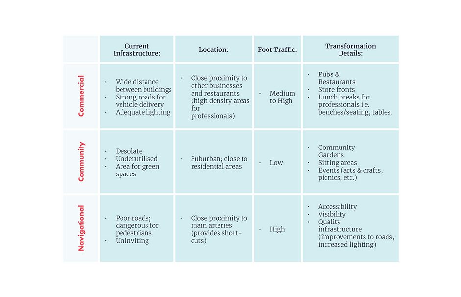
From these observations and findings, I concluded that different alleyways located around the city would need separate interventions depending on the location, foot traffic, and current infrastructure. I summarized these findings into 3 main transformation categories: navigational, community and commercial.
Solution
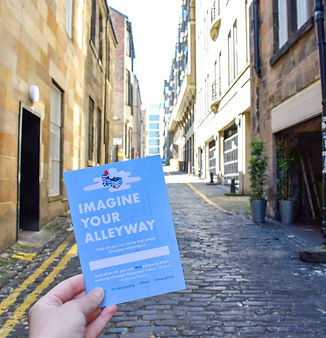
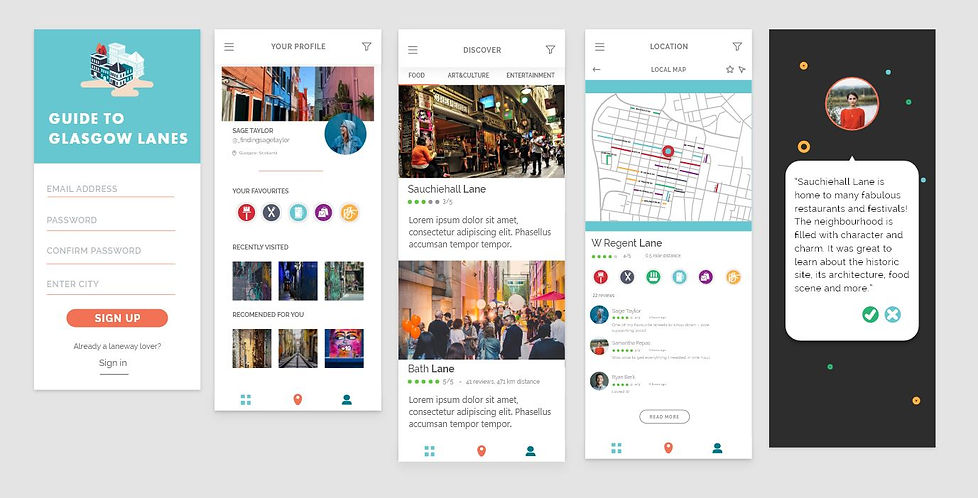
Guide to Glasgow Lanes is a wayfinding app that encourages locals and tourists alike to redirect their route and interact with the City Center in a new and exciting way. Based on the current Glasgow City Council Lane Strategy, I have applied their existing goals and objectives to develop a navigation system specifically for those who are interested in exploring.
Lanes and alleyways are no longer places to avoid or pass through quickly – instead they are to be experienced and enjoyed with friends and family.
User Flow
Main Page
Pedestrians will sign in or create a new account
Profile
Pedestrians will create a profile which includes a list of what their interests are i.e. food, art, music, gardens, etc.
Discover
Pedestrians will learn about new places they are visit and get an idea of the ratings each place has received.
Local Map
The wayfinding app has a built in GPS system so the pedestrian can see where they are in relation to other laneways.
The Guide to Glasgow Lanes app offers a GPS system to help direct navigators to the experience they are seeking. Moreover, a description of what specifically the lane has to offer will be provided and navigators can review their experience for others to read.
This app is intended to expand to areas outside of the Glasgow City Council once interventions have taken place throughout Glasgow.

The Experience
Using the “Lane & Alleyway Assessment Chart” criteria developed when analyzing the current infrastructure of Glasgow alleyways in the Govan, West and City Center, each laneway will offer a unique experience dependent on the intervention that has taken place.
Buccleuch Lane is a primarily residential area with low foot traffic, in which case it falls under the “Community” category. A community garden is recommended for a successful transformative design application. When looking at the Guide to Glasgow Lanes, navigators will reference the green “community garden” line and access a greenspace to spend their afternoon in, if they so chose.